Sunday, 17 May 2015

Case Study: Land Subsistence in the American Southwest

a) Describe the causes of land subsistence in the American Southwest and explain why its getting worse over the years?


Overdrafting of aquifers is a major cause of subsidence in Southwestern United States, and as ground-water pumping increases, land subsidence also will increase. In many aquifers, ground water is pumped from pore spaces between grains of sand and gravel. It's getting worse and worse each year because a large amount of groundwater has been excessively withdrawn from aquifers. For instance the lowered water pressure causes slow drainage from clay and silt beds, it also results in a loss of support for the clay and silt beds, and it can also lower the lands surface.

b) Describe the potential impacts of land subsistence. 


Land subsidence causes many problems including: 


(1) changes in elevation and slope of streams, canals, and drains

(2) damage to bridges, roads, rail roads, storm drains, sanitary sewers, and canals
(3) damage to private and public buildings

(4) failure of well casings from forces generated by compaction of fine-grained materials in aquifer systems. In some coastal areas, subsidence has resulted in tides moving into low-lying areas that were previously above high-tide levels. 


c) Outline ways to prevent further land subsistence.  


In some areas where ground-water pumping has caused subsidence, the subsidence has been stopped by switching from ground-water to surface-water supplies. If surface water is not available, then other means must be taken to reduce subsidence. Possible measures include reducing water use and determining locations for pumping and artificial recharge that will minimize subsidence. Optimization models coupled with ground-water flow models can be used to develop such strategies.

Tuesday, 12 May 2015

Mass Wasting China-Case Study: HONOLULU STAR BULLETIN

HONOLULU STAR BULLETIN

Breaking News, Honolulu! - A massive landslide strikes Zhouqu County, China

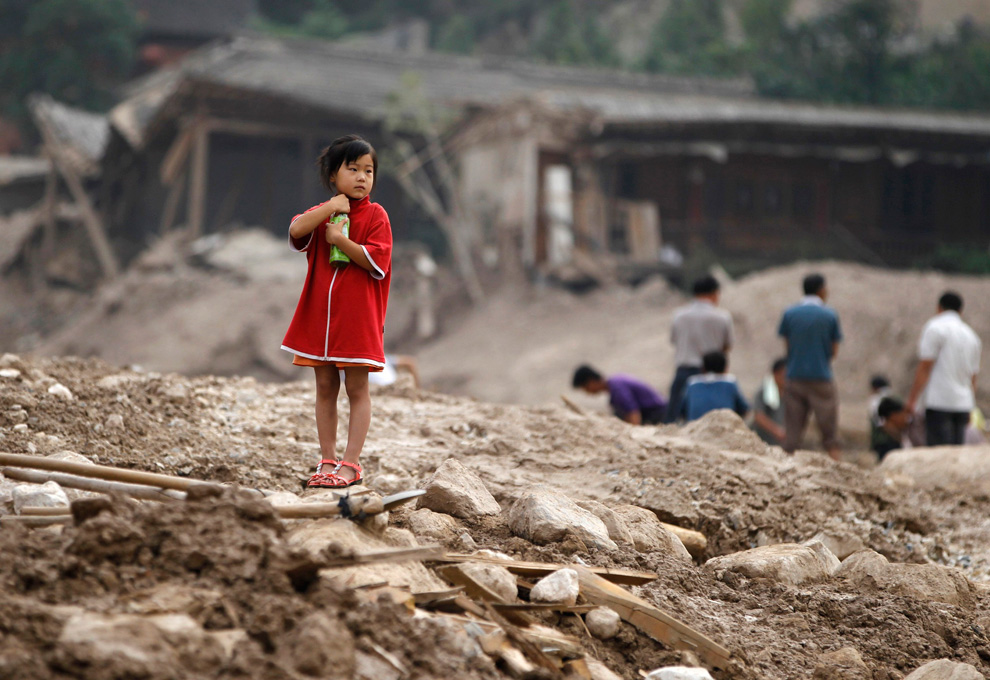
The devasting landslide in Zhouqu, China happend on August 8th. More than 1700  people had been declared dead and 490 people were missing. Villages,buildings, and homes were destroyed. This was recorded as the worst landslide in Zhouqu and possibly the worst in China.


The landslide occurred because of a variety of reasons for instance China`s topography is extremely mountainous. Forests have been logged for trees as an industry, stripping the mountainsides and exposing underlying soils and sediments. The weather has been experiencing torrential rains from the monsoon season. The region also experiences large and devasting earthquakes from time to time.  Landslides occur because of the heavy rainfall and from the earthquakes occurring on steep slopes where the slipping soil causes landslides. The anthropogenic causes of landslides are dams, clear cutting, undercutting, etc.


This landslide was very devastating because it was quite large and it killed or injured many people and animals. It destroyed homes, villages and buildings.


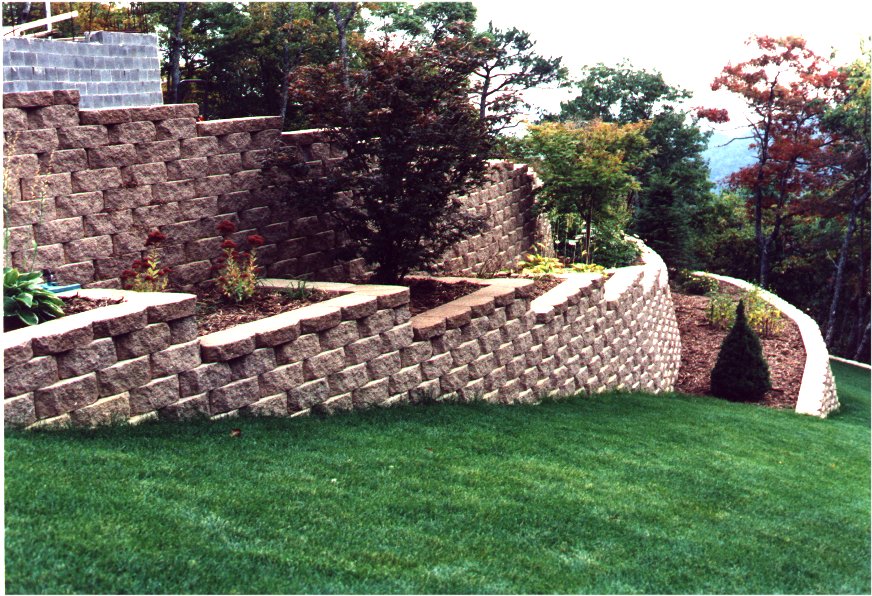
This landslide could've been prevented from stabilizing the ground and by building retaining walls that won't compromise the shear plane of the land.


Communities could've prevented some of the landslide damage by avoiding to build houses on a slope or living close to them. A few tips which would allow people to be prepared for this is by listening to the radio or news, being alert for rocky slopes, being ready to relocate to safer locations, being alert on heavy and continuous rainy days.

Immediately after the landslide,  families should not return to homes because there could be a lot of destruction. After everything has fully recovered and is repaired, then they are allowed to go. Many prevention programs are created to prevent a future disaster. Also, many recovery efforts  and assistance is available from other cities and service workers, for the recovery of a massive landslide such as this one in Zhouqu, China.


Deforestation in Hawaii

1) You are going to research deforestation in your country. Give me some information on it. 

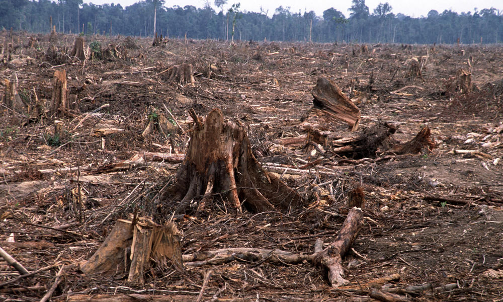
Deforestation is the permanent removal of forest cover from an area.

Deforestation in Hawaii, can cause a lot of damage to the state. Hawaii's native forests are among the Earth's biological treasures, sheltering more than 10,000 unique species. The forests supply Hawaii with fresh water, they protect Hawaii's world class beaches from destructive run off and sediment, and they are an important link to survival of Hawaiian cultural practices. Deforestation can cause animals to be displaced from their homes and many can face extinction because of their destroyed habitat. The lack of oxygen from the removal of the trees could also be a great disadvantage. The number of disadvantages override and definitely weigh more heavily than the number of advantages of deforestation, specifically in Hawaii. Deforestation causes lots of damage to be done.


2) You will explain the Social, Environmental, and Economic Impacts that deforestation has had on your country.

A) Social impacts :
-Deforestation can cause jobs or employment in the community. Many workers are needed to cut down trees and forests with machinery.

-Without trees, humans and animals will not be able to breath in oxygen. This will be a disadvantage to them since oxygen is vital to take in, and carbon dioxide is vital to take out.


B) Environmental Impacts:
-Climate change can be an impact of deforestation because by destroying the trees, there will be an excess of carbon dioxide in the atmosphere. The carbon dioxide will alter the climate of the region for instance cool climates may get hotter and hot climates may get cooler.

-Deforestation may also cause soil erosion destruction because without the trees, the soil will be exposed to the sun's heat. The soil's moisture would dry up, nutrients evaporate, and bacteria that helps to break down products are affected. Eventually, rain washes down soil surfaces and erosion takes place.


C) Economic Impacts
-Deforestation can increase revenue because of furniture or paper products created from the trees. It is a booming industry.

-Can be a very costly project to cut down all the trees.


3) Look at the information in the Environment and Resources folder that talks about Deforestation in Canada. Based on the information provided do you think that deforestation is a greater threat in your country or Canada? Explain your reasoning using specific examples. 

In my opinion I think there is a greater deforestation threat in Hawaii than Canada because Hawaii has many native forests which are among the Earth`s biological treasures which are more sought out when logging. Also, the environmental impact of soil erosion from deforestation is more likely to happen in Hawaii because of the heat causing the soils moisture to dry up unlike Canada where this does not happen as much. Deforestation in Hawaii is a larger threat since it is on an island and therefore special logging supplies tend are needed, which tend to be more expensive which is an economic disadvantage. Canada has 0.02% of  forested area and deforestation in Canada is among the world`s lowest since Canada is a world leader in sustainable forest management. Canadian forests are healthy, productive and thriving compared to Hawaii`s. The state of Hawaii does not have a supreme plan for sustaining forests and that is one major reason why deforestation is a large threat there. Prevention is key and Canada has been setting a good example for other countries and states. Today, Canada`s 348 million hectares of forest lands represent about 9% of the world`s forest cover, but accounts for only 0.3 % of global deforestation. Overall, Canada is less of a threat due to it leading a sustainable forest management project.


Tuesday, 5 May 2015

Aquaculture


1. Define Aquaculture. Aquaculture is also known as aquafarming, it is the farming of aquatic organisms such as fish, crustaceans, molluscs, and aquatic plants. It is the rearing of aquatic animals or cultivation of aquatic plants for food.


2. Look at the Social (on people), environmental, and economic pros and cons of aquaculture. For each of the three you should list 3 pros and 3 cons.
a)Social
Pros:
-Creates jobs/employment in the community
-Feeds a growing population
-Meets increasing consumer demand for seafood

Cons:
-Conflicts with other users of water bodies such as lobsterman, fisherman, or migrating fish
-Can threaten livelihood of fisherman
-Consumers who are eating the fish from fish farms can have an impact on their health because of chemicals ( pesticides & drugs to prevent sickness and disease) in the fish.

b)Environmental
Pros:
-Places more emphasis on protecting coastal waters from pollution, especially in the case of mollusk or seaweed culture
-Fish farms can be made anywhere on the environment such as on coastal areas, inland lakes, and rivers. The farms can be in the form of artificial ponds, enclosures within a natural setting and large tanks.
-Fastest growing method of food production in the environment

Cons:
-Can compromise the aesthetic beauty of coastlines
-Can pollute water systems with excess nutrients ( fish feed & wastes), chemicals and antibiotics
-Contributes to the growing issue of water contamination

c)Economic
Pros:
-Can encourage local investment
-Can increase revenue on city, state, and national level
-Can reduce seafood trade deficit

Cons:
-Can be an unpredictable enterprise for small local communities due to its susceptibility to severe weather, predators, disease and global competition, which can cause an economic loss to the community 
-Can cause a decrease in supply and demand depending on the limited amount of healthy fish or varying consumer demand
-Aquaculture can require a lot of funding

3. Write a short paragraph (7-10 sentences) explaining your point of view on aquaculture. Is it a good thing? A bad thing? Why. Use examples from your pros and cons in #2.

In my perspective, I think aquaculture has a negative impact on most things. It can cause many problems socially, economically and environmentally. Socially, it can conflict with other users of water bodies such as lobsterman, fisherman and even migrating fish. It can cause people to become sick because of the pesticides and drugs put into the fish to prevent pests, sickness and disease. Economically, a decline in supply and demand would not be beneficial to the industry. Also aquaculture could cause an unpredictable enterprise for small local communities due to reasons like severe weather, predators, disease and global competition. Environmentally, it can pollute water systems with excess nutrients and potentially contribute to the growing issue of water contamination. Most importantly aquaculture can harm and can likely compromise the aesthetic beauty of coastlines. Personally, I do not like the idea of people getting sick,  economic losses, and jeopardizing the beautiful environment we have because of aquaculture. I disagree with aquaculture since in my opinion, the cons weigh more heavily than the pros. 

Video link on aquaculture : https://www.youtube.com/watch?v=PPvGumiwtDU

Sunday, 26 April 2015

Case Study: Along the Cascadia Subduction Zone


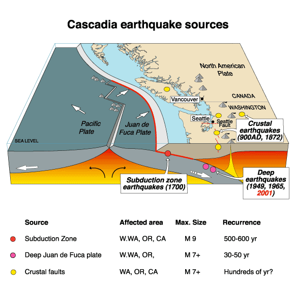
1. We know major earthquakes would occur in the area along the Cascadia subduction zone with the epicentre being near Haida Gwaii in the Juan de Fuca straight based on the evidence of past earthquakes. Vancouver is situated in a seismically active region where massive and destructive earthquakes have occurred in the past.  A major earthquake could occur at any time. The Metro Vancouver region lies at the forefront of the North American plate and on the western edge of the plate, the Juan de Fuca plate is subducting beneath and is slowing deforming the continent. Which is why major earthquakes are able to occur in Metro Vancouver. 

2. The geological setting makes this densely populated region susceptible to frequent seismic activity. This area also has increased risk of disastrous megathrust earthquakes. The Metro Vancouver region is surrounded by the Coast Mountains and the Pacific Ocean making it isolated and vulnerable during a large earthquake. 


https://www.youtube.com/watch?v=Bq1VHnq0Yvk - Video link of city of Vancouver : Are you prepared for an earthquake ?

3.a) 
i) During seismic shaking; groundwater, sand and soil combine to form liquefaction during a powerful earthquake. The result of this process is quicksand like soil. This is a hazard because buildings that have liquefaction under it, can potentially sink and the buildings would collapse. Collapsing infrastructure not only damages the city or area but is a hazard for the lives of humans or animals.


ii) Landslides are triggered by the ground shaking. They are often more destructive than earthquakes because they can cause lots of property damage, injury and death. Varieties of resources can also be ruined for example water supplies, fisheries,sewage disposal systems, forests, dams and roadways can be affected. This would also have a negative impact on the economy to repair and pay for all the damages.


iii) One of the most dangerous effects of an earthquake is a tsunami. They are giant waves that can cause floods and in some cases may reach up to 100 feet in height. These deadly waves strike a great distance from the epicentre. They often result from sub-sea faulting of ocean floor sending seismic shocks through the water. They can cause lots of property and environmental damage and many people's lives are in danger because of such a hazardous event happening.


iv) Flooding can come from many sources such as broken water main pipes, dams that fail due to earthquakes or earthquake-generated tsunamis. Flooding is very dangerous since it can damage buildings, sweep away or drown people.  It negatively impacts the area where the earthquake already has done so much damage.


b)
 i) Earthquakes can have an enormous social impact on humans whether they be short or long term impacts. The short term impacts include people being lost, killed or injured, homes being destroyed, transport/communication links to be disrupted, water pipes bursting and water supplies to be contaminated. Long term impacts may involve disease to spread, people having to re-house sometimes in refugee camps.


ii) Earthquakes can cause a lot of economic impact. Short term impacts may be shops and business' being destroyed, damage to transport and communication links could cause trading to become difficult. Long term impacts involve the cost of rebuilding a settlement to be quite high, investment in the area may be focused on repairing damages and lots of income or major insurance losses.


iii) Earthquakes also negatively impact the infrastructure. It can cause large buildings to collapse and can result in the wreckage of many areas. Bridges, tunnels, skytrains and roads would be destroyed and blocked, which would make it an obstacle to move around. It would make it difficult for search and rescue teams, fire-fighters, police officers, and many more public service workers to help in this situation. Water reservoirs would become contaminated and ruined. Airports would get destroyed resulting in planes to not be able to enter or leave the terminal. Public places would be ruined such as schools and hospitals. If hospitals were destroyed, it would be difficult to treat injured people.


4. Some of the communities in Metro Vancouver  are preparing for the impending earthquake by:
i) By storing food and water at home and at work.
ii) Some have identified a family meeting location and made an emergency preparedness plans or kits.
iii) By stocking up on self powered radios and flashlights.
iv) By fastening shelves securely to walls, and placing heavy objects on lower shelves.
v) By creating more secure buildings or infrastructures/brace hanging light fixtures.
vi) Storing poisons such as pesticides and herbicides, as well as flammable liquids on bottom shelves of latched cabinets.
vii) By repairing any large existing cracks in walls or foundations.
viii) Hanging items such as pictures and mirrors away from beds and anywhere people sit.


https://www.youtube.com/watch?v=t_IWJx-mOw0 - Video link of a documentary on preparedness during an earthquake.

Monday, 20 April 2015

2006 Kiholo Bay earthquake


The 2006 Kiholo Bay earthquake happened on Sunday, October 15, 2006 at 7:07:48 am in the Hawaii region about 20 km NNE of Kailua Kona, Hawai'i, Hawaii. The Kiholo Bay earthquake was a large, deep mantle earthquake. The focus of the earthquake was  the mantle. It  had quite a depth therefore it was a deep focus earthquake. The weight of the islands caused the earthquake to occur because of load and stress/bend of the brittle lithosphere, generating stresses that drive the earthquake faulting into the mantle. It was primarily 
caused by underground rock suddenly breaking along a fault. The Richter scale magnitude of the Kiholo Bay earthquake is 6.7. The earthquake caused a lot of damage to Hawaii. The biosphere was affected because plants were destroyed and animals lost their homes as well as their lives were in danger. The lithosphere including roads and mountains have been negatively impacted by breaking or things falling over them.The economic impact of the earthquake was paying millions of dollars in order to fix the damages. The earthquake also had a negative impact on the infrastructure as it ruined and completely destroyed buildings, roads, overpasses, and bridges. 


Saturday, 18 April 2015

Plate Tectonics off the coast of BC


Map of the plates of the World
The Juan de Fuca Plate is located off the coast of British Columbia in Canada. It is a tectonic plate which has generated from the Juan de Fuca Ridge and is subducting under the northerly portion of the western side of the North American Plate at the Casacadia subduction zone. It has its origins with Panthalassa's oceanic basin and crust. This oceanic crust has primarily been subducted under the North American plate and the Eurasian Plate.The plate is bounded on the south by the Blanco Fracture Zone ( coast of Oregan,USA), on the north by the Nootka Fault (near Vancouver  Island, BC,Canada) and along the west by the Pacific Plate (which covers most of Pacific ocean). The Juan de Fuca has all three types of dynamic plate boundaries occurring within a  small area. The three types of dynamic plate boundaries are the convergent, divergent, and the transform boundaries.
Plates along the coast of Western side of North America
 Juan de Fuca plate, moves east-northwest about 4 cm per year. It is actively subducting beneath North America, its motion is not smooth. It is more sticky, and strain builds up until the fault breaks and a few meters of Juan De Fuca gets slid under North America in a big earthquake. 
Ring of Fire : area of where earthquakes and volcanoes are formed

The associated hazards with the Juan De Fuca Plates are volcanoes and earthquakes  which form from the pacific ring of fire.Faults form in rocks when the stresses overcome the internal strength of the rock resulting in a fracture. A fault can be defined as the displacement of once connected blocks along a fault plane. Below, is an example of folds and faults in British Columbia, Canada and also, in Alberta, British Columbia.


Muskwa and Sukunka River are located in British Columbia whereas Highwood River is located in Alberta