Sunday 26 April 2015

Case Study: Along the Cascadia Subduction Zone


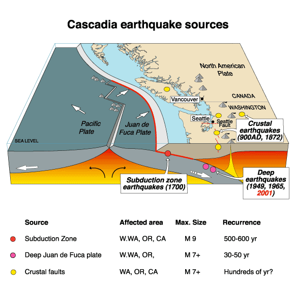
1. We know major earthquakes would occur in the area along the Cascadia subduction zone with the epicentre being near Haida Gwaii in the Juan de Fuca straight based on the evidence of past earthquakes. Vancouver is situated in a seismically active region where massive and destructive earthquakes have occurred in the past.  A major earthquake could occur at any time. The Metro Vancouver region lies at the forefront of the North American plate and on the western edge of the plate, the Juan de Fuca plate is subducting beneath and is slowing deforming the continent. Which is why major earthquakes are able to occur in Metro Vancouver. 

2. The geological setting makes this densely populated region susceptible to frequent seismic activity. This area also has increased risk of disastrous megathrust earthquakes. The Metro Vancouver region is surrounded by the Coast Mountains and the Pacific Ocean making it isolated and vulnerable during a large earthquake. 


https://www.youtube.com/watch?v=Bq1VHnq0Yvk - Video link of city of Vancouver : Are you prepared for an earthquake ?

3.a) 
i) During seismic shaking; groundwater, sand and soil combine to form liquefaction during a powerful earthquake. The result of this process is quicksand like soil. This is a hazard because buildings that have liquefaction under it, can potentially sink and the buildings would collapse. Collapsing infrastructure not only damages the city or area but is a hazard for the lives of humans or animals.


ii) Landslides are triggered by the ground shaking. They are often more destructive than earthquakes because they can cause lots of property damage, injury and death. Varieties of resources can also be ruined for example water supplies, fisheries,sewage disposal systems, forests, dams and roadways can be affected. This would also have a negative impact on the economy to repair and pay for all the damages.


iii) One of the most dangerous effects of an earthquake is a tsunami. They are giant waves that can cause floods and in some cases may reach up to 100 feet in height. These deadly waves strike a great distance from the epicentre. They often result from sub-sea faulting of ocean floor sending seismic shocks through the water. They can cause lots of property and environmental damage and many people's lives are in danger because of such a hazardous event happening.


iv) Flooding can come from many sources such as broken water main pipes, dams that fail due to earthquakes or earthquake-generated tsunamis. Flooding is very dangerous since it can damage buildings, sweep away or drown people.  It negatively impacts the area where the earthquake already has done so much damage.


b)
 i) Earthquakes can have an enormous social impact on humans whether they be short or long term impacts. The short term impacts include people being lost, killed or injured, homes being destroyed, transport/communication links to be disrupted, water pipes bursting and water supplies to be contaminated. Long term impacts may involve disease to spread, people having to re-house sometimes in refugee camps.


ii) Earthquakes can cause a lot of economic impact. Short term impacts may be shops and business' being destroyed, damage to transport and communication links could cause trading to become difficult. Long term impacts involve the cost of rebuilding a settlement to be quite high, investment in the area may be focused on repairing damages and lots of income or major insurance losses.


iii) Earthquakes also negatively impact the infrastructure. It can cause large buildings to collapse and can result in the wreckage of many areas. Bridges, tunnels, skytrains and roads would be destroyed and blocked, which would make it an obstacle to move around. It would make it difficult for search and rescue teams, fire-fighters, police officers, and many more public service workers to help in this situation. Water reservoirs would become contaminated and ruined. Airports would get destroyed resulting in planes to not be able to enter or leave the terminal. Public places would be ruined such as schools and hospitals. If hospitals were destroyed, it would be difficult to treat injured people.


4. Some of the communities in Metro Vancouver  are preparing for the impending earthquake by:
i) By storing food and water at home and at work.
ii) Some have identified a family meeting location and made an emergency preparedness plans or kits.
iii) By stocking up on self powered radios and flashlights.
iv) By fastening shelves securely to walls, and placing heavy objects on lower shelves.
v) By creating more secure buildings or infrastructures/brace hanging light fixtures.
vi) Storing poisons such as pesticides and herbicides, as well as flammable liquids on bottom shelves of latched cabinets.
vii) By repairing any large existing cracks in walls or foundations.
viii) Hanging items such as pictures and mirrors away from beds and anywhere people sit.


https://www.youtube.com/watch?v=t_IWJx-mOw0 - Video link of a documentary on preparedness during an earthquake.

Monday 20 April 2015

2006 Kiholo Bay earthquake


The 2006 Kiholo Bay earthquake happened on Sunday, October 15, 2006 at 7:07:48 am in the Hawaii region about 20 km NNE of Kailua Kona, Hawai'i, Hawaii. The Kiholo Bay earthquake was a large, deep mantle earthquake. The focus of the earthquake was  the mantle. It  had quite a depth therefore it was a deep focus earthquake. The weight of the islands caused the earthquake to occur because of load and stress/bend of the brittle lithosphere, generating stresses that drive the earthquake faulting into the mantle. It was primarily 
caused by underground rock suddenly breaking along a fault. The Richter scale magnitude of the Kiholo Bay earthquake is 6.7. The earthquake caused a lot of damage to Hawaii. The biosphere was affected because plants were destroyed and animals lost their homes as well as their lives were in danger. The lithosphere including roads and mountains have been negatively impacted by breaking or things falling over them.The economic impact of the earthquake was paying millions of dollars in order to fix the damages. The earthquake also had a negative impact on the infrastructure as it ruined and completely destroyed buildings, roads, overpasses, and bridges. 


Saturday 18 April 2015

Plate Tectonics off the coast of BC


Map of the plates of the World
The Juan de Fuca Plate is located off the coast of British Columbia in Canada. It is a tectonic plate which has generated from the Juan de Fuca Ridge and is subducting under the northerly portion of the western side of the North American Plate at the Casacadia subduction zone. It has its origins with Panthalassa's oceanic basin and crust. This oceanic crust has primarily been subducted under the North American plate and the Eurasian Plate.The plate is bounded on the south by the Blanco Fracture Zone ( coast of Oregan,USA), on the north by the Nootka Fault (near Vancouver  Island, BC,Canada) and along the west by the Pacific Plate (which covers most of Pacific ocean). The Juan de Fuca has all three types of dynamic plate boundaries occurring within a  small area. The three types of dynamic plate boundaries are the convergent, divergent, and the transform boundaries.
Plates along the coast of Western side of North America
 Juan de Fuca plate, moves east-northwest about 4 cm per year. It is actively subducting beneath North America, its motion is not smooth. It is more sticky, and strain builds up until the fault breaks and a few meters of Juan De Fuca gets slid under North America in a big earthquake. 
Ring of Fire : area of where earthquakes and volcanoes are formed

The associated hazards with the Juan De Fuca Plates are volcanoes and earthquakes  which form from the pacific ring of fire.Faults form in rocks when the stresses overcome the internal strength of the rock resulting in a fracture. A fault can be defined as the displacement of once connected blocks along a fault plane. Below, is an example of folds and faults in British Columbia, Canada and also, in Alberta, British Columbia.


Muskwa and Sukunka River are located in British Columbia whereas Highwood River is located in Alberta


Impact of Fishing


A)

i) Fishermen heavily depend on the fishing industry. They depend on fishing as a career and it is a way to feed their families. Fishing has a positive impact for fishermen because it is their job and without them, consumers would not get the fish and the government wouldn't be happy as they want profit and money.

Fishing is beneficial to fishermen because it is how they get paid, its their job.

ii) Consumers depend on fishing for food and everyday eating. Some people also eat fish for certain health benefits such as getting vitamins, minerals or fatty acids ie. Omega-3. Fishing is a positive impact for consumers as it is a in demand food for fish lovers. Fish is used in many delicacies and many restaurants use fish in their main meals. 
Consumers benefit from fishing as they love to eat fish.


iii) Governments also depend on the fishing industry as it is a means of profit. They can make a lot of money from fishing companies. Fishing is a positive impact for government as people will pay lots of money to buy them causing fishing industries to flourish.

Government also benefits from fishing, as it helps them make profit.

iv) With the impact of fishing, environmentalists are concerned about marine environments as it could disrupt food webs by targeting specific in demand species. Ecological disruption would be a negative impact of fishing. 

Environmentalists are not too happy with fishing as they think it can lead to over fishing which can cause marine environments to be destroyed.

B) 

The state of Hawaii is surrounded by water which results in the fishing industry to be pretty well off and successful. This major fishing industry is centered in the port of Honolulu, which receives seventy two percent of the total Hawaii fishing landings. According to scientists, Hawaii has been impacted by overfishing causing a steep decline as it affected three-quarter of the species once commonly found on coral reefs. Sharks, jacks, parrot fish, and other colorful reef fish are quickly disappearing from coral reefs encircling the Hawaiian Islands. Climate change also resulted in coral reefs to be in danger causing a steady decline in coral reef ecosystems. Seventy five percent of fish species in Hawaii are in critical condition. Species depletion would negatively impact Hawaii as there will be a lack of balance and biodiversity. Depletion of species of fish will cause fishing industries to decline as there would not be enough supply for the demand from the consumers

Fishing in Hawaii